De Forest night lights from space
Night Light of De Forest (Wisconsin) from space (United States) Src. Average luminocity for 10x10km area is 23.3864% and for 50x50km: 15.6009%.
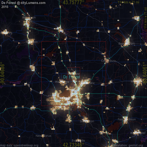
Analysis of De Forest night lights 2016
Square area 10x10 km:
 1.21%
1.21%90-99
1.52%80-89
2.58%70-79
3.18%60-69
3.03%50-59
5%40-49
3.79%30-39
5%20-29
9.24%10-19
29.24%0-9
36.21%Square area 50x50 km:
2.16%90-99
2.27%80-89
2.23%70-79
2.2%60-69
2.39%50-59
2.8%40-49
2.3%30-39
2.61%20-29
4.4%10-19
6.54%0-9
70.1%Clear (daylight) street map image can be seen on geolist.org.
Map coordinates:
43° 45' 28" North, 90° 2' 48.7" West
43° 14' 52" North, 89° 20' 37.4" West
42° 44' 0.5" North, 88° 38' 26.2" West
Some cities around De Forest sort by population:
• Madison
20 km =12.4 mi,  193°
193°
• Sun Prairie
12.7 km =7.9 mi,  124°
124°
• Middleton
21.2 km =13.2 mi,  217°
217°
• Waunakee
11 km =6.8 mi,  235°
235°
• Verona
32.4 km =20.1 mi,  208°
208°
• McFarland
26.5 km =16.5 mi,  170°
170°
• Monona
20.6 km =12.8 mi,  177°
177°
• Cottage Grove
22.4 km =13.9 mi,  148°
148°
5250188 (p: 8,936)
Sources (retrieved 2019-11-25):
» Earth at Night: Flat Maps 2012, 2016