Waterville night lights from space
Night Light of Waterville (Ohio) from space (United States) Src. Average luminocity for 10x10km area is 30.6395% and for 50x50km: 25.4999%.
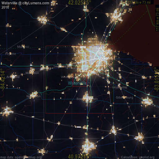
Analysis of Waterville night lights 2016
Square area 10x10 km:
 0.68%
0.68%90-99
1.36%80-89
3.23%70-79
3.74%60-69
7.14%50-59
10.03%40-49
7.31%30-39
5.27%20-29
12.07%10-19
27.04%0-9
22.11%Square area 50x50 km:
6.17%90-99
5.93%80-89
3.05%70-79
3.31%60-69
3.75%50-59
2.65%40-49
2.39%30-39
2.35%20-29
3.72%10-19
7.65%0-9
59.03%Clear (daylight) street map image can be seen on geolist.org.
Map coordinates:
42° 1' 31.3" North, 84° 25' 17" West
41° 30' 3.2" North, 83° 43' 5.8" West
40° 58' 19.7" North, 83° 0' 54.5" West
Some cities around Waterville sort by population:
• Toledo
22.6 km =14 mi,  36°
36°
• Bowling Green
15.1 km =9.4 mi,  158°
158°
• Perrysburg
9.8 km =6.1 mi,  50°
50°
• Oregon
24.9 km =15.5 mi, 50°
• Sylvania
24.2 km =15 mi,  1°
1°
• Maumee
8.7 km =5.4 mi, 37°
• Rossford
17.6 km =10.9 mi, 46°
• Northwood
23.9 km =14.9 mi,  60°
60°
5175847 (p: 5,514)
Sources (retrieved 2019-11-25):
» Earth at Night: Flat Maps 2012, 2016