Washougal night lights from space
Night Light of Washougal (Washington) from space (United States) Src. Average luminocity for 10x10km area is 34.5879% and for 50x50km: 26.9389%.
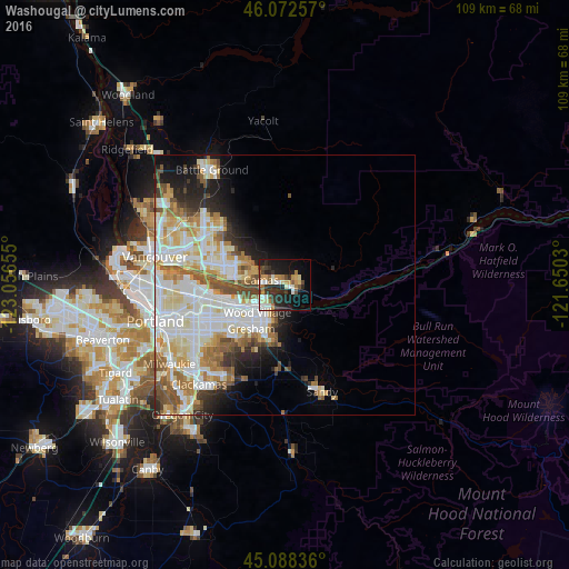
Analysis of Washougal night lights 2016
Square area 10x10 km:
 4.24%
4.24%90-99
6.36%80-89
4.09%70-79
5.91%60-69
4.09%50-59
3.18%40-49
3.64%30-39
7.27%20-29
14.55%10-19
22.12%0-9
24.55%Square area 50x50 km:
6.94%90-99
7.43%80-89
3.45%70-79
3.35%60-69
3.11%50-59
3.13%40-49
2.27%30-39
1.62%20-29
3.54%10-19
5.66%0-9
59.49%Clear (daylight) street map image can be seen on geolist.org.
Map coordinates:
46° 4' 21.3" North, 123° 3' 23.6" West
45° 34' 57.4" North, 122° 21' 12.3" West
45° 5' 18.1" North, 121° 39' 1.1" West
Some cities around Washougal sort by population:
• Gresham
11.2 km =7 mi,  212°
212°
• Camas
3.6 km =2.2 mi,  277°
277°
• Lents
20.2 km =12.6 mi,  235°
235°
• Orchards
18.6 km =11.6 mi,  300°
300°
• Troutdale
5.5 km =3.4 mi, 208°
• Damascus
20.1 km =12.5 mi,  204°
204°
• Fairview
8 km =5 mi,  231°
231°
• Mill Plain
12.8 km =8 mi, 301°
5815136 (p: 15,288)
Sources (retrieved 2019-11-25):
» Earth at Night: Flat Maps 2012, 2016