Orchards night lights from space
Night Light of Orchards (Washington) from space (United States) Src. Average luminocity for 10x10km area is 82.5697% and for 50x50km: 36.3045%.
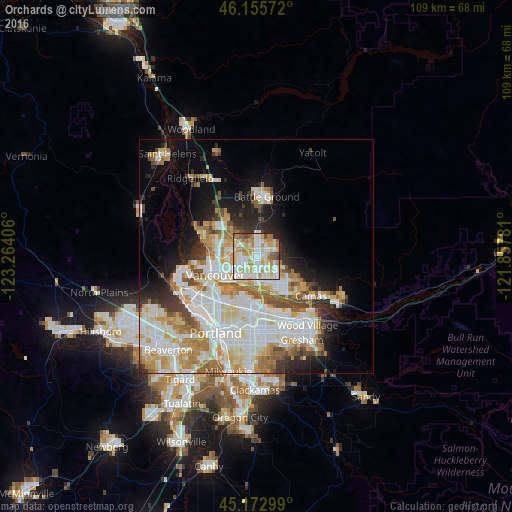
Analysis of Orchards night lights 2016
Square area 10x10 km:
 20.76%
90-99
27.58%80-89
15.61%70-79
14.24%60-69
8.48%50-59
5.91%40-49
2.88%30-39
1.82%20-29
2.27%10-19
0.45%0-9
0%Square area 50x50 km:
9.5%90-99
10.02%80-89
4.72%70-79
4.92%60-69
4.2%50-59
3.05%40-49
2.85%30-39
2.45%20-29
4.55%10-19
7.58%0-9
46.15%Clear (daylight) street map image can be seen on geolist.org.
Map coordinates:
46° 9' 20.6" North, 123° 15' 50.6" West
45° 39' 59.4" North, 122° 33' 39.3" West
45° 10' 22.8" North, 121° 51' 28.1" West
Some cities around Orchards sort by population:
• Vancouver
8.4 km =5.2 mi,  248°
248°
• Salmon Creek
8.4 km =5.2 mi,  305°
305°
• Hazel Dell
7.9 km =4.9 mi,  274°
274°
• Five Corners
2.3 km =1.4 mi,  331°
331°
• Walnut Grove
3 km =1.9 mi, 272°
• Minnehaha
6.9 km =4.3 mi,  263°
263°
• Mill Plain
5.8 km =3.6 mi,  116°
116°
• Barberton
4.2 km =2.6 mi,  315°
315°
5805815 (p: 19,556)
Sources (retrieved 2019-11-25):
» Earth at Night: Flat Maps 2012, 2016