Damascus night lights from space
Night Light of Damascus (Oregon) from space (United States) Src. Average luminocity for 10x10km area is 20.6841% and for 50x50km: 32.3242%.
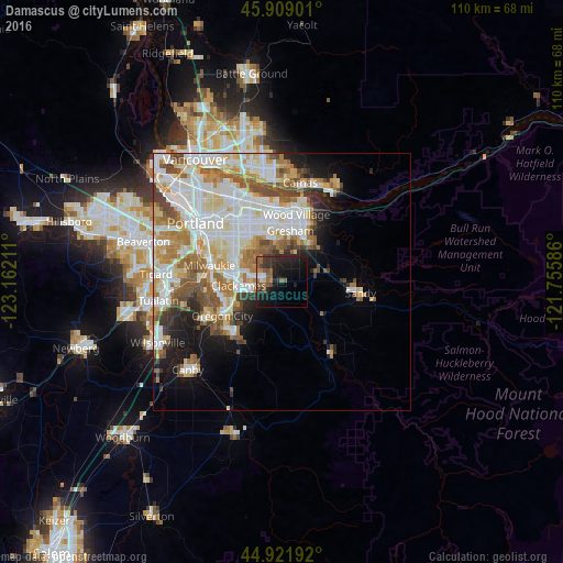
Analysis of Damascus night lights 2016
Square area 10x10 km:
 0.79%
0.79%90-99
1.9%80-89
0.48%70-79
0.95%60-69
4.6%50-59
7.78%40-49
1.27%30-39
6.19%20-29
10.63%10-19
23.97%0-9
41.43%Square area 50x50 km:
8.71%90-99
8.71%80-89
3.73%70-79
3.76%60-69
4.2%50-59
4.02%40-49
3.26%30-39
1.85%20-29
3.26%10-19
6.54%0-9
51.95%Clear (daylight) street map image can be seen on geolist.org.
Map coordinates:
45° 54' 32.4" North, 123° 9' 43.6" West
45° 25' 3.4" North, 122° 27' 32.3" West
44° 55' 18.9" North, 121° 45' 21.1" West
Some cities around Damascus sort by population:
• Gresham
9.2 km =5.7 mi,  13°
13°
• Oregon City
13.3 km =8.3 mi,  239°
239°
• Lents
10.9 km =6.8 mi,  309°
309°
• Happy Valley
6.4 km =4 mi,  300°
300°
• Oatfield
11 km =6.8 mi,  268°
268°
• Gladstone
11.4 km =7.1 mi,  248°
248°
• Jennings Lodge
12.3 km =7.6 mi,  256°
256°
• Clackamas
8.8 km =5.5 mi, 262°
5722088 (p: 10,952)
Sources (retrieved 2019-11-25):
» Earth at Night: Flat Maps 2012, 2016