Wakefield-Peacedale night lights from space
Night Light of Wakefield-Peacedale (Rhode Island) from space (United States) Src. Average luminocity for 10x10km area is 26.1565% and for 50x50km: 9.8435%.
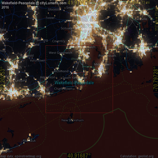
Analysis of Wakefield-Peacedale night lights 2016
Square area 10x10 km:
 1.19%
1.19%90-99
3.4%80-89
4.59%70-79
3.74%60-69
3.06%50-59
2.89%40-49
5.78%30-39
4.93%20-29
2.38%10-19
41.16%0-9
26.87%Square area 50x50 km:
0.77%90-99
1.21%80-89
1.25%70-79
0.96%60-69
1.23%50-59
1.48%40-49
1.75%30-39
1.8%20-29
3.67%10-19
9.72%0-9
76.17%Clear (daylight) street map image can be seen on geolist.org.
Map coordinates:
41° 58' 15.5" North, 72° 12' 12.7" West
41° 26' 45.8" North, 71° 30' 1.4" West
40° 55' 0.7" North, 70° 47' 50.2" West
Some cities around Wakefield-Peacedale sort by population:
• South Kingstown
2 km =1.2 mi,  273°
273°
• North Kingstown
11.9 km =7.4 mi,  13°
13°
• Newport
16.4 km =10.2 mi,  72°
72°
• Narragansett
4.3 km =2.7 mi,  83°
83°
• Charlestown
13.7 km =8.5 mi,  239°
239°
• Kingston
4.2 km =2.6 mi,  334°
334°
• Exeter
14.9 km =9.3 mi,  348°
348°
• Jamestown
12.5 km =7.8 mi,  62°
62°
7257663 (p: 8,487)
Sources (retrieved 2019-11-25):
» Earth at Night: Flat Maps 2012, 2016