Newport night lights from space
Night Light of Newport (Rhode Island) from space (United States) Src. Average luminocity for 10x10km area is 43.4711% and for 50x50km: 15.4185%.
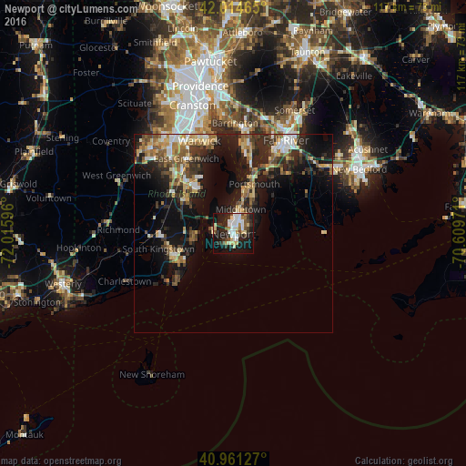

Analysis of Newport night lights 2016
Square area 10x10 km:
 10.71%
90-99
9.86%80-89
6.12%70-79
2.04%60-69
2.72%50-59
3.57%40-49
5.44%30-39
6.12%20-29
15.48%10-19
30.1%0-9
7.82%Square area 50x50 km:
1.62%90-99
2.24%80-89
2.07%70-79
1.87%60-69
2.13%50-59
2.39%40-49
2.31%30-39
2.6%20-29
5.52%10-19
12.04%0-9
65.21%Clear (daylight) street map image can be seen on geolist.org.
Map coordinates:
42° 0' 52.7" North, 72° 0' 57.5" West
41° 29' 24.4" North, 71° 18' 46.2" West
40° 57' 40.6" North, 70° 36' 35" West
Some cities around Newport sort by population:
• North Kingstown
14.4 km =8.9 mi,  297°
297°
• Portsmouth
13.5 km =8.4 mi,  22°
22°
• Middletown
6.4 km =4 mi, 16°
• Narragansett
12.2 km =7.6 mi,  248°
248°
• Wakefield-Peacedale
16.4 km =10.2 mi, 252°
• Tiverton
17.2 km =10.7 mi,  28°
28°
• Kingston
17.5 km =10.9 mi,  266°
266°
• Jamestown
4.6 km =2.9 mi,  279°
279°
5223593 (p: 24,232)
Sources (retrieved 2019-11-25):
» Earth at Night: Flat Maps 2012, 2016