Narragansett night lights from space
Night Light of Narragansett (Rhode Island) from space (United States) Src. Average luminocity for 10x10km area is 23.318% and for 50x50km: 10.1419%.
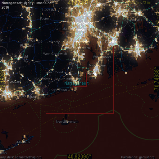
Analysis of Narragansett night lights 2016
Square area 10x10 km:
 0.85%
0.85%90-99
2.55%80-89
3.91%70-79
3.91%60-69
3.57%50-59
3.23%40-49
5.61%30-39
2.89%20-29
2.04%10-19
32.31%0-9
39.12%Square area 50x50 km:
0.78%90-99
1.22%80-89
1.3%70-79
1.05%60-69
1.32%50-59
1.67%40-49
1.79%30-39
1.84%20-29
3.78%10-19
9.54%0-9
75.69%Clear (daylight) street map image can be seen on geolist.org.
Map coordinates:
41° 58' 29.9" North, 72° 9' 9.5" West
41° 27' 0.4" North, 71° 26' 58.2" West
40° 55' 15.4" North, 70° 44' 47" West
Some cities around Narragansett sort by population:
• South Kingstown
6.3 km =3.9 mi,  267°
267°
• North Kingstown
11.2 km =7 mi,  352°
352°
• Newport
12.2 km =7.6 mi,  68°
68°
• Newport East
15.3 km =9.5 mi,  61°
61°
• Wakefield-Peacedale
4.3 km =2.7 mi,  263°
263°
• Kingston
7 km =4.3 mi,  298°
298°
• Exeter
16 km =9.9 mi,  332°
332°
• Jamestown
8.6 km =5.3 mi,  52°
52°
5223505 (p: 15,868)
Sources (retrieved 2019-11-25):
» Earth at Night: Flat Maps 2012, 2016