Waimanalo night lights from space
Night Light of Waimanalo (Hawaii) from space (United States) Src. Average luminocity for 10x10km area is 26.7197% and for 50x50km: 11.9103%.
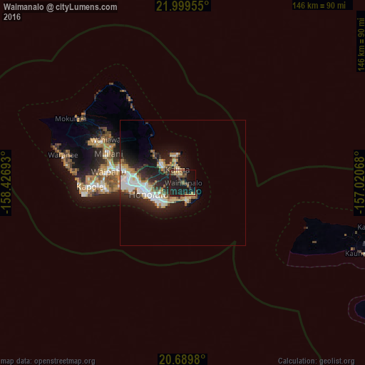
Analysis of Waimanalo night lights 2016
Square area 10x10 km:
 0.19%
0.19%90-99
0.19%80-89
4.36%70-79
3.98%60-69
3.03%50-59
6.06%40-49
6.44%30-39
3.98%20-29
11.17%10-19
44.7%0-9
15.91%Square area 50x50 km:
2.12%90-99
2.36%80-89
1.34%70-79
1.48%60-69
1.15%50-59
1.19%40-49
1.3%30-39
1.53%20-29
4.45%10-19
8.29%0-9
74.77%Clear (daylight) street map image can be seen on geolist.org.
Map coordinates:
21° 59' 58.4" North, 158° 25' 36.9" West
21° 20' 46.1" North, 157° 43' 25.7" West
20° 41' 23.3" North, 157° 1' 14.4" West
Some cities around Waimanalo sort by population:
• Honolulu
14.6 km =9.1 mi,  252°
252°
• East Honolulu
6.4 km =4 mi,  173°
173°
• Kailua
6.5 km =4 mi,  344°
344°
• Kaneohe
9.8 km =6.1 mi,  307°
307°
• Hālawa
20.8 km =12.9 mi,  280°
280°
• Hālawa Heights
20 km =12.4 mi, 280°
• Marine Corps Base Hawaii - MCBH
11.1 km =6.9 mi,  346°
346°
• ‘Āhuimanu
16.1 km =10 mi, 312°
5854532 (p: 5,451)
Sources (retrieved 2019-11-25):
» Earth at Night: Flat Maps 2012, 2016