Villa Rica night lights from space
Night Light of Villa Rica (Georgia) from space (United States) Src. Average luminocity for 10x10km area is 56.9634% and for 50x50km: 34.0683%.
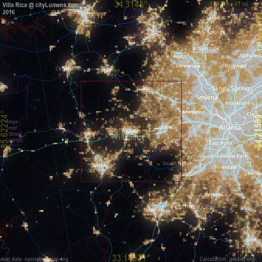
Analysis of Villa Rica night lights 2016
Square area 10x10 km:
 6.41%
6.41%90-99
9.89%80-89
8.79%70-79
11.9%60-69
6.78%50-59
10.81%40-49
9.71%30-39
11.9%20-29
23.81%10-19
0%0-9
0%Square area 50x50 km:
2.43%90-99
3.04%80-89
4.27%70-79
6.99%60-69
9.94%50-59
6.59%40-49
5.11%30-39
7.04%20-29
8.51%10-19
15.49%0-9
30.57%Clear (daylight) street map image can be seen on geolist.org.
Map coordinates:
34° 18' 53.3" North, 85° 37' 20.1" West
33° 43' 55.4" North, 84° 55' 8.8" West
33° 8' 43.1" North, 84° 12' 57.6" West
Some cities around Villa Rica sort by population:
• Mableton
32.6 km =20.3 mi,  72°
72°
• Douglasville
16 km =9.9 mi,  82°
82°
• Carrollton
22.3 km =13.9 mi,  220°
220°
• Lithia Springs
24.9 km =15.5 mi, 73°
• Powder Springs
26 km =16.2 mi,  56°
56°
• Dallas
22.5 km =14 mi,  18°
18°
• Austell
27.8 km =17.3 mi, 71°
• Bremen
21 km =13 mi,  266°
266°
4228452 (p: 14,904)
Sources (retrieved 2019-11-25):
» Earth at Night: Flat Maps 2012, 2016