Dallas night lights from space
Night Light of Dallas (Georgia) from space (United States) Src. Average luminocity for 10x10km area is 50.9196% and for 50x50km: 45.1174%.
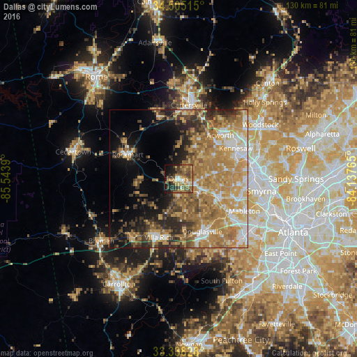
Analysis of Dallas night lights 2016
Square area 10x10 km:
 3.85%
3.85%90-99
3.85%80-89
7.17%70-79
13.64%60-69
11.36%50-59
14.34%40-49
9.09%30-39
9.97%20-29
9.97%10-19
14.16%0-9
2.62%Square area 50x50 km:
5.33%90-99
6.3%80-89
6.9%70-79
11.53%60-69
12.39%50-59
6.7%40-49
4.8%30-39
5.62%20-29
6.3%10-19
8.58%0-9
25.56%Clear (daylight) street map image can be seen on geolist.org.
Map coordinates:
34° 30' 18.5" North, 85° 32' 38" West
33° 55' 25.4" North, 84° 50' 26.8" West
33° 20' 17.8" North, 84° 8' 15.5" West
Some cities around Dallas sort by population:
• Mableton
26.6 km =16.5 mi,  116°
116°
• Kennesaw
23.5 km =14.6 mi,  61°
61°
• Douglasville
21 km =13 mi,  155°
155°
• Acworth
21.8 km =13.5 mi,  43°
43°
• Lithia Springs
22 km =13.7 mi,  130°
130°
• Villa Rica
22.5 km =14 mi,  198°
198°
• Powder Springs
16.1 km =10 mi, 116°
• Austell
22.7 km =14.1 mi, 122°
4190598 (p: 12,870)
Sources (retrieved 2019-11-25):
» Earth at Night: Flat Maps 2012, 2016