Versailles night lights from space
Night Light of Versailles (Kentucky) from space (United States) Src. Average luminocity for 10x10km area is 25.6867% and for 50x50km: 21.9035%.
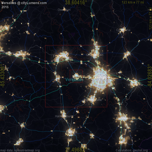
Analysis of Versailles night lights 2016
Square area 10x10 km:
 2.6%
2.6%90-99
3.57%80-89
4.38%70-79
6.01%60-69
1.62%50-59
1.79%40-49
2.76%30-39
2.27%20-29
4.55%10-19
31.82%0-9
38.64%Square area 50x50 km:
4.48%90-99
5.18%80-89
2.42%70-79
1.95%60-69
1.83%50-59
2.04%40-49
2.5%30-39
3.39%20-29
6.15%10-19
12.61%0-9
57.45%Clear (daylight) street map image can be seen on geolist.org.
Map coordinates:
38° 36' 15" North, 85° 25' 59.1" West
38° 3' 9.3" North, 84° 43' 47.8" West
37° 29' 48.6" North, 84° 1' 36.6" West
Some cities around Versailles sort by population:
• Lexington-Fayette
23.8 km =14.8 mi,  90°
90°
• Lexington
23.2 km =14.4 mi,  107°
107°
• Georgetown
23 km =14.3 mi,  40°
40°
• Nicholasville
23.6 km =14.7 mi,  144°
144°
• Frankfort
20.7 km =12.9 mi,  322°
322°
• Lawrenceburg
14.7 km =9.1 mi,  263°
263°
• Wilmore
22 km =13.7 mi,  164°
164°
• Monticello
17.1 km =10.6 mi, 113°
4312057 (p: 9,146)
Sources (retrieved 2019-11-25):
» Earth at Night: Flat Maps 2012, 2016