Lawrenceburg night lights from space
Night Light of Lawrenceburg (Kentucky) from space (United States) Src. Average luminocity for 10x10km area is 25.1672% and for 50x50km: 8.1624%.
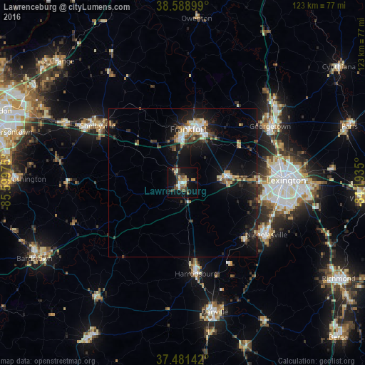
Analysis of Lawrenceburg night lights 2016
Square area 10x10 km:
 1.62%
1.62%90-99
3.25%80-89
3.57%70-79
3.73%60-69
2.11%50-59
6.01%40-49
3.25%30-39
7.31%20-29
2.44%10-19
25.65%0-9
41.07%Square area 50x50 km:
0.81%90-99
1.05%80-89
0.91%70-79
0.99%60-69
0.69%50-59
0.95%40-49
1.13%30-39
1.7%20-29
2.42%10-19
8.43%0-9
80.92%Clear (daylight) street map image can be seen on geolist.org.
Map coordinates:
38° 35' 20.4" North, 85° 35' 59.1" West
38° 2' 14.3" North, 84° 53' 47.8" West
37° 28' 53.1" North, 84° 11' 36.6" West
Some cities around Lawrenceburg sort by population:
• Georgetown
35.2 km =21.9 mi,  57°
57°
• Nicholasville
33.3 km =20.7 mi,  121°
121°
• Frankfort
18.3 km =11.4 mi,  6°
6°
• Shelbyville
34.6 km =21.5 mi,  304°
304°
• Versailles
14.7 km =9.1 mi,  83°
83°
• Harrodsburg
30.9 km =19.2 mi,  171°
171°
• Wilmore
28.4 km =17.6 mi,  133°
133°
• Monticello
30.8 km =19.1 mi,  99°
99°
4297581 (p: 11,103)
Sources (retrieved 2019-11-25):
» Earth at Night: Flat Maps 2012, 2016