University Park night lights from space
Night Light of University Park (Florida) from space (United States) Src. Average luminocity for 10x10km area is 99.7746% and for 50x50km: 55.0185%.
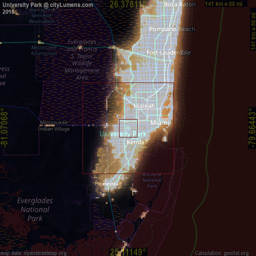
Analysis of University Park night lights 2016
Square area 10x10 km:
 86.74%
90-99
13.26%80-89
0%70-79
0%60-69
0%50-59
0%40-49
0%30-39
0%20-29
0%10-19
0%0-9
0%Square area 50x50 km:
27.96%90-99
9.85%80-89
2.38%70-79
3.42%60-69
8.77%50-59
4.79%40-49
3.56%30-39
3.03%20-29
3.69%10-19
5.21%0-9
27.34%Clear (daylight) street map image can be seen on geolist.org.
Map coordinates:
26° 22' 41.2" North, 81° 4' 14.4" West
25° 44' 47.4" North, 80° 22' 3.2" West
25° 6' 41.4" North, 79° 39' 51.9" West
Some cities around University Park sort by population:
• Fountainebleau
3.5 km =2.2 mi,  33°
33°
• Tamiami
3.4 km =2.1 mi,  293°
293°
• Flagami
5.4 km =3.4 mi,  71°
71°
• Westchester
4.1 km =2.5 mi,  77°
77°
• Sweetwater
2 km =1.2 mi,  343°
343°
• Sunset
4.8 km =3 mi,  161°
161°
• Olympia Heights
2.5 km =1.6 mi,  150°
150°
• Westwood Lake
2 km =1.2 mi,  195°
195°
4176217 (p: 26,995)
Sources (retrieved 2019-11-25):
» Earth at Night: Flat Maps 2012, 2016