Olympia Heights night lights from space
Night Light of Olympia Heights (Florida) from space (United States) Src. Average luminocity for 10x10km area is 99.8409% and for 50x50km: 54.2501%.
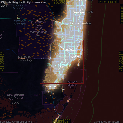
Analysis of Olympia Heights night lights 2016
Square area 10x10 km:
 89.39%
90-99
10.61%80-89
0%70-79
0%60-69
0%50-59
0%40-49
0%30-39
0%20-29
0%10-19
0%0-9
0%Square area 50x50 km:
26.6%90-99
9.47%80-89
2.42%70-79
3.44%60-69
9.21%50-59
5.1%40-49
4.24%30-39
3.31%20-29
3.66%10-19
5.59%0-9
26.98%Clear (daylight) street map image can be seen on geolist.org.
Map coordinates:
26° 21' 30.6" North, 81° 3' 30.5" West
25° 43' 36.4" North, 80° 21' 19.2" West
25° 5' 30" North, 79° 39' 8" West
Some cities around Olympia Heights sort by population:
• Fountainebleau
5.2 km =3.2 mi,  8°
8°
• Westchester
4.2 km =2.6 mi,  42°
42°
• University Park
2.5 km =1.6 mi,  330°
330°
• Coral Terrace
5.5 km =3.4 mi,  67°
67°
• Sweetwater
4.4 km =2.7 mi,  336°
336°
• Glenvar Heights
3.7 km =2.3 mi,  125°
125°
• Sunset
2.3 km =1.4 mi,  172°
172°
• Westwood Lake
1.8 km =1.1 mi,  279°
279°
4166979 (p: 13,488)
Sources (retrieved 2019-11-25):
» Earth at Night: Flat Maps 2012, 2016