Twin Rivers night lights from space
Night Light of Twin Rivers (New Jersey) from space (United States) Src. Average luminocity for 10x10km area is 47.0666% and for 50x50km: 50.8682%.
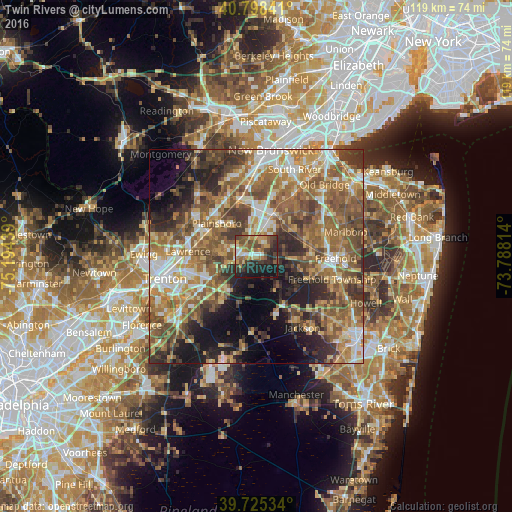
Analysis of Twin Rivers night lights 2016
Square area 10x10 km:
 3.9%
3.9%90-99
5.52%80-89
5.19%70-79
7.95%60-69
11.36%50-59
11.04%40-49
7.79%30-39
11.04%20-29
17.21%10-19
18.51%0-9
0.49%Square area 50x50 km:
6.07%90-99
7.26%80-89
7.37%70-79
8.48%60-69
11.8%50-59
12.93%40-49
8.69%30-39
8.17%20-29
8.78%10-19
9.59%0-9
10.87%Clear (daylight) street map image can be seen on geolist.org.
Map coordinates:
40° 47' 54.3" North, 75° 11' 39.8" West
40° 15' 50.4" North, 74° 29' 28.5" West
39° 43' 31.2" North, 73° 47' 17.3" West
Some cities around Twin Rivers sort by population:
• Mercerville-Hamilton Square
15.8 km =9.8 mi,  256°
256°
• Princeton Meadows
9.7 km =6 mi,  320°
320°
• Hamilton Square
14.3 km =8.9 mi,  253°
253°
• Dayton
12.2 km =7.6 mi,  352°
352°
• Yorketown
13.9 km =8.6 mi,  69°
69°
• Jamesburg
10.8 km =6.7 mi,  23°
23°
• Heathcote
15.6 km =9.7 mi,  332°
332°
• Hightstown
2.8 km =1.7 mi,  282°
282°
5105594 (p: 7,443)
Sources (retrieved 2019-11-25):
» Earth at Night: Flat Maps 2012, 2016