Hamilton Square night lights from space
Night Light of Hamilton Square (New Jersey) from space (United States) Src. Average luminocity for 10x10km area is 76.1834% and for 50x50km: 47.7891%.
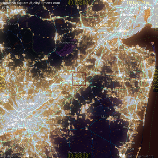
Analysis of Hamilton Square night lights 2016
Square area 10x10 km:
 16.72%
90-99
15.58%80-89
13.47%70-79
13.96%60-69
17.69%50-59
13.96%40-49
6.01%30-39
2.6%20-29
0%10-19
0%0-9
0%Square area 50x50 km:
6.68%90-99
8.01%80-89
7.43%70-79
8.72%60-69
10.05%50-59
8.78%40-49
6.66%30-39
6.49%20-29
7.69%10-19
11.67%0-9
17.82%Clear (daylight) street map image can be seen on geolist.org.
Map coordinates:
40° 45' 43.3" North, 75° 21' 22.8" West
40° 13' 38.4" North, 74° 39' 11.6" West
39° 41' 18.2" North, 73° 57' 0.3" West
Some cities around Hamilton Square sort by population:
• Trenton
7.7 km =4.8 mi,  261°
261°
• Mercerville-Hamilton Square
1.7 km =1.1 mi,  285°
285°
• Mercerville
3 km =1.9 mi, 290°
• White Horse
5.8 km =3.6 mi,  225°
225°
• Morrisville
11.6 km =7.2 mi, 261°
• Yardville
5.2 km =3.2 mi,  190°
190°
• Prospect Park
9.7 km =6 mi,  278°
278°
• Hightstown
12 km =7.5 mi,  66°
66°
5098781 (p: 12,784)
Sources (retrieved 2019-11-25):
» Earth at Night: Flat Maps 2012, 2016