Yorketown night lights from space
Night Light of Yorketown (New Jersey) from space (United States) Src. Average luminocity for 10x10km area is 58.2228% and for 50x50km: 55.1574%.
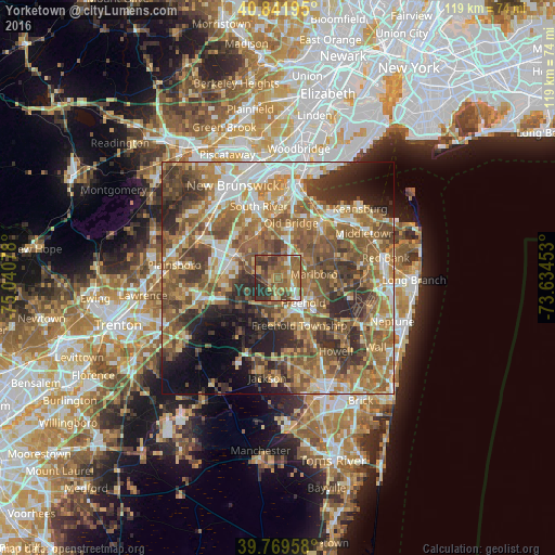
Analysis of Yorketown night lights 2016
Square area 10x10 km:
 3.74%
3.74%90-99
4.42%80-89
5.95%70-79
9.86%60-69
25%50-59
19.39%40-49
11.56%30-39
11.39%20-29
8.67%10-19
0%0-9
0%Square area 50x50 km:
6.71%90-99
8.35%80-89
7.52%70-79
8.98%60-69
13.43%50-59
14.74%40-49
9.19%30-39
9.06%20-29
8.71%10-19
6.83%0-9
6.48%Clear (daylight) street map image can be seen on geolist.org.
Map coordinates:
40° 50' 31" North, 75° 2' 26.8" West
40° 18' 28.4" North, 74° 20' 15.5" West
39° 46' 10.5" North, 73° 38' 4.3" West
Some cities around Yorketown sort by population:
• Marlboro
7.8 km =4.8 mi,  83°
83°
• South Old Bridge
11.2 km =7 mi,  352°
352°
• West Freehold
7.9 km =4.9 mi,  157°
157°
• Freehold
7.6 km =4.7 mi,  134°
134°
• Robertsville
6 km =3.7 mi,  44°
44°
• Spotswood
10.7 km =6.6 mi,  331°
331°
• Jamesburg
10 km =6.2 mi,  299°
299°
• Morganville
11 km =6.8 mi,  46°
46°
5106645 (p: 6,535)
Sources (retrieved 2019-11-25):
» Earth at Night: Flat Maps 2012, 2016