Dayton night lights from space
Night Light of Dayton (New Jersey) from space (United States) Src. Average luminocity for 10x10km area is 69.7551% and for 50x50km: 58.6871%.
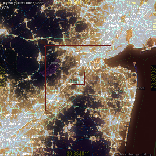
Analysis of Dayton night lights 2016
Square area 10x10 km:
 14.46%
90-99
16.33%80-89
10.54%70-79
7.48%60-69
6.8%50-59
18.2%40-49
17.01%30-39
9.18%20-29
0%10-19
0%0-9
0%Square area 50x50 km:
10.72%90-99
11.37%80-89
8.08%70-79
9.42%60-69
11.93%50-59
12.24%40-49
7.7%30-39
7.35%20-29
6.52%10-19
6.07%0-9
8.61%Clear (daylight) street map image can be seen on geolist.org.
Map coordinates:
40° 54' 22.1" North, 75° 12' 47.8" West
40° 22' 21.4" North, 74° 30' 36.5" West
39° 50' 5.3" North, 73° 48' 25.3" West
Some cities around Dayton sort by population:
• East Brunswick
10.1 km =6.3 mi,  52°
52°
• Princeton Meadows
6.4 km =4 mi,  225°
225°
• Franklin Park
7.7 km =4.8 mi,  343°
343°
• Kendall Park
6.9 km =4.3 mi,  321°
321°
• Spotswood
9.7 km =6 mi,  77°
77°
• Milltown
10.9 km =6.8 mi,  31°
31°
• Jamesburg
6.3 km =3.9 mi,  110°
110°
• Heathcote
5.8 km =3.6 mi,  287°
287°
5097152 (p: 7,063)
Sources (retrieved 2019-11-25):
» Earth at Night: Flat Maps 2012, 2016