Trenton night lights from space
Night Light of Trenton (Ohio) from space (United States) Src. Average luminocity for 10x10km area is 43.2532% and for 50x50km: 40.8238%.
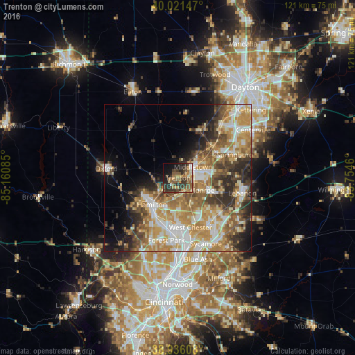
Analysis of Trenton night lights 2016
Square area 10x10 km:
 2.11%
2.11%90-99
3.57%80-89
5.03%70-79
7.79%60-69
8.28%50-59
13.47%40-49
9.09%30-39
17.21%20-29
10.88%10-19
13.8%0-9
8.77%Square area 50x50 km:
6.38%90-99
8.22%80-89
5.38%70-79
8.3%60-69
7.43%50-59
6.29%40-49
5.18%30-39
6.15%20-29
6.73%10-19
6.61%0-9
33.33%Clear (daylight) street map image can be seen on geolist.org.
Map coordinates:
40° 1' 17.3" North, 85° 9' 39.1" West
39° 28' 51.2" North, 84° 27' 27.8" West
38° 56' 9.9" North, 83° 45' 16.6" West
Some cities around Trenton sort by population:
• Hamilton
12.7 km =7.9 mi,  224°
224°
• Middletown
6.4 km =4 mi,  53°
53°
• Fairfield
17.4 km =10.8 mi,  210°
210°
• Monroe
9.4 km =5.8 mi,  118°
118°
• Franklin
15.8 km =9.8 mi,  56°
56°
• Beckett Ridge
15 km =9.3 mi,  172°
172°
• Germantown
17.8 km =11.1 mi,  25°
25°
• Carlisle
16.3 km =10.1 mi, 46°
4526469 (p: 12,281)
Sources (retrieved 2019-11-25):
» Earth at Night: Flat Maps 2012, 2016