Topanga night lights from space
Night Light of Topanga (California) from space (United States) Src. Average luminocity for 10x10km area is 28.7857% and for 50x50km: 49.7634%.
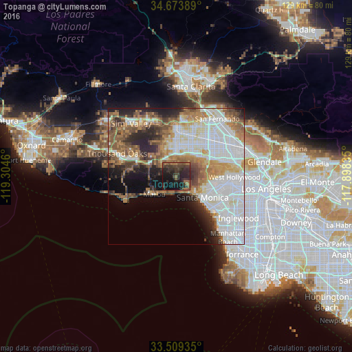
Analysis of Topanga night lights 2016
Square area 10x10 km:
 0%
0%90-99
0%80-89
0%70-79
0.55%60-69
7.14%50-59
6.59%40-49
8.61%30-39
17.77%20-29
23.63%10-19
32.05%0-9
3.66%Square area 50x50 km:
17.12%90-99
10.35%80-89
4.04%70-79
5.07%60-69
7.89%50-59
6.03%40-49
5.08%30-39
4.44%20-29
6.89%10-19
7.59%0-9
25.49%Clear (daylight) street map image can be seen on geolist.org.
Map coordinates:
34° 40' 26" North, 119° 18' 16.6" West
34° 5' 37" North, 118° 36' 5.3" West
33° 30' 33.7" North, 117° 53' 54.1" West
Some cities around Topanga sort by population:
• Santa Monica
13.1 km =8.1 mi,  129°
129°
• Woodland Hills
8.3 km =5.2 mi,  357°
357°
• Canoga Park
12 km =7.5 mi,  1°
1°
• Encino
11.8 km =7.3 mi,  51°
51°
• West Hills
12.2 km =7.6 mi,  341°
341°
• Calabasas
7.9 km =4.9 mi,  334°
334°
• Agoura
13.7 km =8.5 mi,  293°
293°
• Las Flores
7 km =4.3 mi,  206°
206°
5402961 (p: 8,289)
Sources (retrieved 2019-11-25):
» Earth at Night: Flat Maps 2012, 2016