Dowagiac night lights from space
Night Light of Dowagiac (Michigan) from space (United States) Src. Average luminocity for 10x10km area is 12.819% and for 50x50km: 6.1621%.
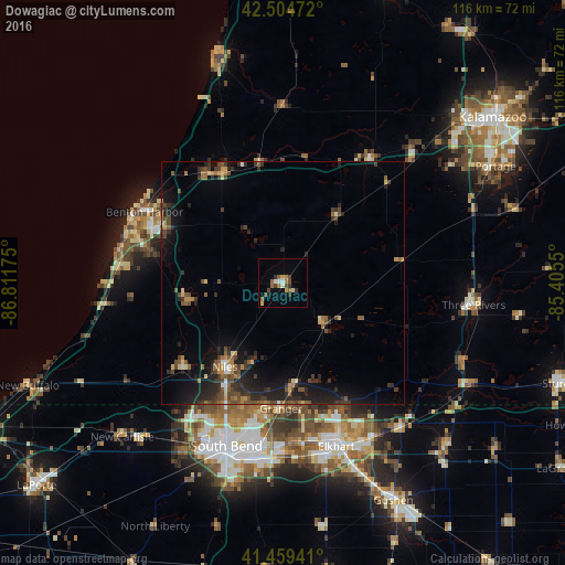
Analysis of Dowagiac night lights 2016
Square area 10x10 km:
 1.27%
1.27%90-99
1.11%80-89
1.11%70-79
1.59%60-69
2.38%50-59
3.17%40-49
2.22%30-39
2.38%20-29
1.59%10-19
0.79%0-9
82.38%Square area 50x50 km:
0.15%90-99
0.36%80-89
0.57%70-79
0.56%60-69
0.84%50-59
1.32%40-49
1.52%30-39
1.41%20-29
2.78%10-19
4.96%0-9
85.51%Clear (daylight) street map image can be seen on geolist.org.
Map coordinates:
42° 30' 17" North, 86° 48' 42.3" West
41° 59' 3.2" North, 86° 6' 31" West
41° 27' 33.9" North, 85° 24' 19.8" West
Some cities around Dowagiac sort by population:
• South Bend
35.4 km =22 mi,  199°
199°
• Elkhart
35.3 km =21.9 mi,  161°
161°
• Granger
25.7 km =16 mi,  180°
180°
• Niles
21 km =13 mi,  215°
215°
• Benton Harbor
32.1 km =19.9 mi,  297°
297°
• Saint Joseph
33.7 km =20.9 mi,  294°
294°
• Fair Plain
30.9 km =19.2 mi, 291°
• Notre Dame
33.3 km =20.7 mi, 198°
4991111 (p: 5,851)
Sources (retrieved 2019-11-25):
» Earth at Night: Flat Maps 2012, 2016