Westwood night lights from space
Night Light of Westwood (Michigan) from space (United States) Src. Average luminocity for 10x10km area is 59.1136% and for 50x50km: 10.9475%.
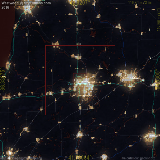
Analysis of Westwood night lights 2016
Square area 10x10 km:
 15.15%
90-99
12.42%80-89
5.45%70-79
6.82%60-69
10.91%50-59
10%40-49
8.18%30-39
5.61%20-29
10.3%10-19
11.36%0-9
3.79%Square area 50x50 km:
1.29%90-99
1.47%80-89
1.14%70-79
1.2%60-69
1.93%50-59
2.11%40-49
2.31%30-39
1.86%20-29
2.59%10-19
4.85%0-9
79.24%Clear (daylight) street map image can be seen on geolist.org.
Map coordinates:
42° 49' 14.5" North, 86° 20' 12.3" West
42° 18' 10.2" North, 85° 38' 1" West
41° 46' 50.3" North, 84° 55' 49.8" West
Some cities around Westwood sort by population:
• Kalamazoo
4 km =2.5 mi,  107°
107°
• Battle Creek
37.5 km =23.3 mi,  87°
87°
• Portage
12.1 km =7.5 mi,  158°
158°
• Three Rivers
39.9 km =24.8 mi,  179°
179°
• Eastwood
6.9 km =4.3 mi, 89°
• Comstock Northwest
9.8 km =6.1 mi,  77°
77°
• Springfield
32.5 km =20.2 mi, 85°
• Allegan
31.1 km =19.3 mi,  324°
324°
5014706 (p: 8,653)
Sources (retrieved 2019-11-25):
» Earth at Night: Flat Maps 2012, 2016