Tenafly night lights from space
Night Light of Tenafly (New Jersey) from space (United States) Src. Average luminocity for 10x10km area is 82.6429% and for 50x50km: 79.5321%.
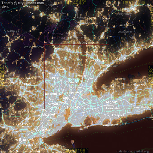
Analysis of Tenafly night lights 2016
Square area 10x10 km:
 18.54%
90-99
24.83%80-89
10.54%70-79
21.43%60-69
19.39%50-59
4.59%40-49
0.68%30-39
0%20-29
0%10-19
0%0-9
0%Square area 50x50 km:
34.22%90-99
17.74%80-89
7.53%70-79
9%60-69
12.25%50-59
5.81%40-49
3.09%30-39
3.54%20-29
3.97%10-19
2.36%0-9
0.51%Clear (daylight) street map image can be seen on geolist.org.
Map coordinates:
41° 27' 16.2" North, 74° 39' 57.8" West
40° 55' 31.4" North, 73° 57' 46.5" West
40° 23' 31.2" North, 73° 15' 35.3" West
Some cities around Tenafly sort by population:
• Englewood
3.7 km =2.3 mi,  192°
192°
• Bergenfield
2.9 km =1.8 mi,  274°
274°
• Dumont
3.3 km =2.1 mi,  300°
300°
• New Milford
4.8 km =3 mi,  282°
282°
• Cresskill
1.8 km =1.1 mi,  9°
9°
• Closter
5.3 km =3.3 mi,  1°
1°
• Englewood Cliffs
4.5 km =2.8 mi,  168°
168°
• Demarest
3.6 km =2.2 mi,  359°
359°
5105300 (p: 14,880)
Sources (retrieved 2019-11-25):
» Earth at Night: Flat Maps 2012, 2016