Closter night lights from space
Night Light of Closter (New Jersey) from space (United States) Src. Average luminocity for 10x10km area is 68.9983% and for 50x50km: 72.8381%.
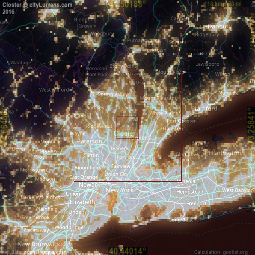
Analysis of Closter night lights 2016
Square area 10x10 km:
 6.29%
6.29%90-99
8.67%80-89
6.46%70-79
21.6%60-69
28.57%50-59
21.09%40-49
5.27%30-39
2.04%20-29
0%10-19
0%0-9
0%Square area 50x50 km:
25.76%90-99
16.49%80-89
7.79%70-79
9.47%60-69
12.67%50-59
6.91%40-49
4.13%30-39
4.33%20-29
5.89%10-19
4.19%0-9
2.37%Clear (daylight) street map image can be seen on geolist.org.
Map coordinates:
41° 30' 6.8" North, 74° 39' 52.8" West
40° 58' 23.3" North, 73° 57' 41.5" West
40° 26' 24.5" North, 73° 15' 30.3" West
Some cities around Closter sort by population:
• Dumont
4.7 km =2.9 mi,  219°
219°
• Tenafly
5.3 km =3.3 mi,  181°
181°
• River Vale
4.9 km =3 mi,  300°
300°
• Cresskill
3.5 km =2.2 mi, 176°
• Emerson
5.4 km =3.4 mi,  273°
273°
• Old Tappan
4.9 km =3 mi,  329°
329°
• Norwood
2.8 km =1.7 mi,  359°
359°
• Demarest
1.8 km =1.1 mi,  185°
185°
5096742 (p: 8,662)
Sources (retrieved 2019-11-25):
» Earth at Night: Flat Maps 2012, 2016