Dumont night lights from space
Night Light of Dumont (New Jersey) from space (United States) Src. Average luminocity for 10x10km area is 83.0952% and for 50x50km: 77.8473%.
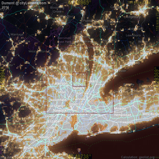
Analysis of Dumont night lights 2016
Square area 10x10 km:
 16.16%
90-99
22.79%80-89
17.86%70-79
25.51%60-69
12.93%50-59
4.76%40-49
0%30-39
0%20-29
0%10-19
0%0-9
0%Square area 50x50 km:
30.66%90-99
17.65%80-89
7.85%70-79
10.24%60-69
12.79%50-59
6.31%40-49
3.3%30-39
3.58%20-29
4.14%10-19
1.95%0-9
1.53%Clear (daylight) street map image can be seen on geolist.org.
Map coordinates:
41° 28' 10.7" North, 74° 41' 59.8" West
40° 56' 26.3" North, 73° 59' 48.5" West
40° 24' 26.6" North, 73° 17' 37.3" West
Some cities around Dumont sort by population:
• Bergenfield
1.5 km =0.9 mi,  181°
181°
• New Milford
2 km =1.2 mi,  251°
251°
• Tenafly
3.3 km =2.1 mi,  120°
120°
• River Edge
3.9 km =2.4 mi, 249°
• Cresskill
3.2 km =2 mi,  88°
88°
• Closter
4.7 km =2.9 mi,  39°
39°
• Oradell
3.9 km =2.4 mi,  300°
300°
• Demarest
3.4 km =2.1 mi,  56°
56°
5097357 (p: 18,001)
Sources (retrieved 2019-11-25):
» Earth at Night: Flat Maps 2012, 2016