Englewood Cliffs night lights from space
Night Light of Englewood Cliffs (New Jersey) from space (United States) Src. Average luminocity for 10x10km area is 91.301% and for 50x50km: 83.2138%.
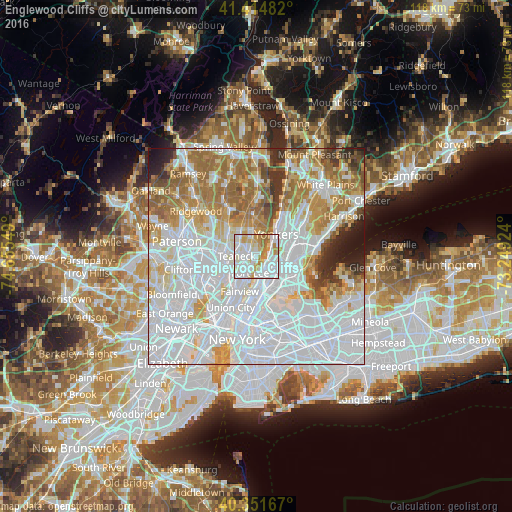
Analysis of Englewood Cliffs night lights 2016
Square area 10x10 km:
 39.29%
90-99
30.27%80-89
8.84%70-79
12.59%60-69
8.33%50-59
0.68%40-49
0%30-39
0%20-29
0%10-19
0%0-9
0%Square area 50x50 km:
40.63%90-99
18.17%80-89
6.71%70-79
8.55%60-69
11.15%50-59
4.89%40-49
2.44%30-39
2.99%20-29
2.59%10-19
1.88%0-9
0.01%Clear (daylight) street map image can be seen on geolist.org.
Map coordinates:
41° 24' 53.4" North, 74° 39' 19.8" West
40° 53' 7.4" North, 73° 57' 8.5" West
40° 21' 6" North, 73° 14' 57.3" West
Some cities around Englewood Cliffs sort by population:
• Washington Heights
4.2 km =2.6 mi,  160°
160°
• Kings Bridge
4 km =2.5 mi,  100°
100°
• Fort Lee
4.1 km =2.5 mi,  201°
201°
• Tenafly
4.5 km =2.8 mi,  348°
348°
• Spuyten Duyvil
3 km =1.9 mi, 98°
• Inwood
3.1 km =1.9 mi,  135°
135°
• Leonia
4 km =2.5 mi,  228°
228°
• Riverdale
4.2 km =2.6 mi,  66°
66°
5097677 (p: 5,403)
Sources (retrieved 2019-11-25):
» Earth at Night: Flat Maps 2012, 2016