Templeton night lights from space
Night Light of Templeton (California) from space (United States) Src. Average luminocity for 10x10km area is 14.4212% and for 50x50km: 3.6349%.
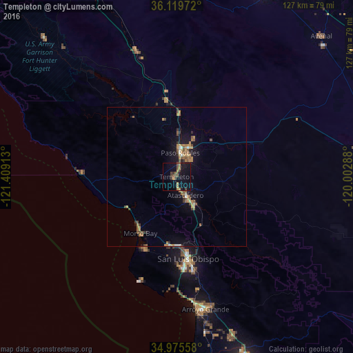
Analysis of Templeton night lights 2016
Square area 10x10 km:
 0%
0%90-99
0%80-89
0%70-79
4.03%60-69
1.28%50-59
4.58%40-49
2.75%30-39
4.21%20-29
0.37%10-19
15.2%0-9
67.58%Square area 50x50 km:
0.13%90-99
0.23%80-89
0.15%70-79
0.9%60-69
0.86%50-59
0.8%40-49
0.56%30-39
0.51%20-29
0.25%10-19
2.57%0-9
93.05%Clear (daylight) street map image can be seen on geolist.org.
Map coordinates:
36° 7' 11" North, 121° 24' 32.9" West
35° 32' 58.9" North, 120° 42' 21.6" West
34° 58' 32.1" North, 120° 0' 10.4" West
Some cities around Templeton sort by population:
• San Luis Obispo
30 km =18.6 mi,  171°
171°
• Atascadero
7.4 km =4.6 mi,  154°
154°
• Paso Robles
8.7 km =5.4 mi,  9°
9°
• Los Osos
28.9 km =18 mi,  203°
203°
• Grover Beach
48.2 km =30 mi, 170°
• Morro Bay
24.2 km =15 mi,  212°
212°
• Pismo Beach
45.6 km =28.3 mi, 172°
• Cambria
33.9 km =21.1 mi,  272°
272°
5401516 (p: 7,674)
Sources (retrieved 2019-11-25):
» Earth at Night: Flat Maps 2012, 2016