Blauvelt night lights from space
Night Light of Blauvelt (New York) from space (United States) Src. Average luminocity for 10x10km area is 68.2273% and for 50x50km: 57.3961%.
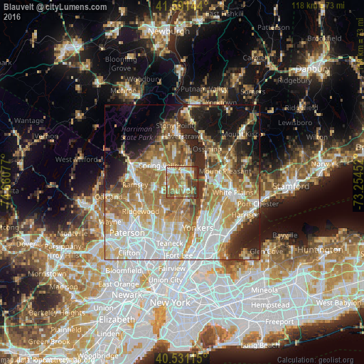
Analysis of Blauvelt night lights 2016
Square area 10x10 km:
 8.6%
8.6%90-99
10.39%80-89
10.39%70-79
12.34%60-69
26.79%50-59
13.8%40-49
9.09%30-39
7.14%20-29
1.46%10-19
0%0-9
0%Square area 50x50 km:
14.27%90-99
11.33%80-89
6.93%70-79
8.98%60-69
12.64%50-59
7.28%40-49
4.57%30-39
5.07%20-29
7.92%10-19
10.44%0-9
10.58%Clear (daylight) street map image can be seen on geolist.org.
Map coordinates:
41° 35' 29.2" North, 74° 39' 38.8" West
41° 3' 48.3" North, 73° 57' 27.5" West
40° 31' 52.1" North, 73° 15' 16.3" West
Some cities around Blauvelt sort by population:
• Nanuet
5.5 km =3.4 mi,  300°
300°
• Pearl River
5.4 km =3.4 mi,  264°
264°
• Valley Cottage
6.1 km =3.8 mi,  1°
1°
• Montvale
5.8 km =3.6 mi,  251°
251°
• Nyack
4.5 km =2.8 mi,  47°
47°
• Tappan
4.7 km =2.9 mi,  169°
169°
• Old Tappan
6.5 km =4 mi,  205°
205°
• Norwood
7.3 km =4.5 mi,  182°
182°
5109479 (p: 5,689)
Sources (retrieved 2019-11-25):
» Earth at Night: Flat Maps 2012, 2016