Taft night lights from space
Night Light of Taft (California) from space (United States) Src. Average luminocity for 10x10km area is 26.1958% and for 50x50km: 5.2192%.
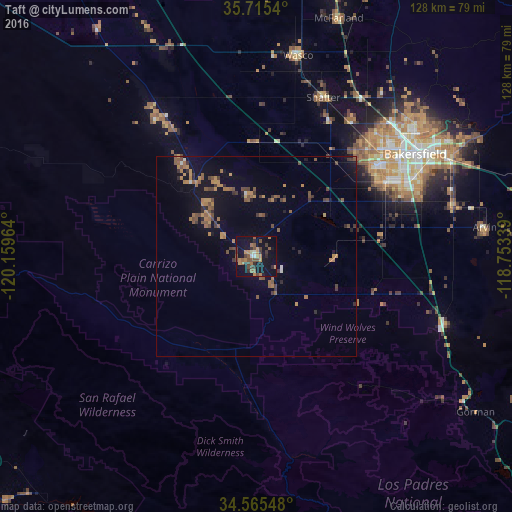
Analysis of Taft night lights 2016
Square area 10x10 km:
 1.22%
1.22%90-99
0.87%80-89
0.7%70-79
5.59%60-69
6.12%50-59
6.47%40-49
6.99%30-39
5.24%20-29
4.02%10-19
31.12%0-9
31.64%Square area 50x50 km:
0.09%90-99
0.16%80-89
0.06%70-79
1.06%60-69
1.2%50-59
1.33%40-49
1.35%30-39
0.96%20-29
0.74%10-19
4.02%0-9
89.03%Clear (daylight) street map image can be seen on geolist.org.
Map coordinates:
35° 42' 55.4" North, 120° 9' 34.7" West
35° 8' 32.9" North, 119° 27' 23.4" West
34° 33' 55.7" North, 118° 45' 12.2" West
Some cities around Taft sort by population:
• Bakersfield
47.3 km =29.4 mi,  57°
57°
• Oildale
50.2 km =31.2 mi,  52°
52°
• Wasco
51.3 km =31.9 mi,  11°
11°
• Arvin
57.6 km =35.8 mi,  82°
82°
• Shafter
43.2 km =26.8 mi,  22°
22°
• Lamont
51 km =31.7 mi, 75°
• Rosedale
38.9 km =24.2 mi, 46°
• Greenacres
41.3 km =25.7 mi, 49°
5400877 (p: 9,495)
Sources (retrieved 2019-11-25):
» Earth at Night: Flat Maps 2012, 2016