Shafter night lights from space
Night Light of Shafter (California) from space (United States) Src. Average luminocity for 10x10km area is 17.0037% and for 50x50km: 15.0329%.
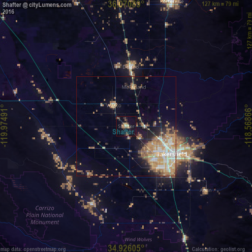
Analysis of Shafter night lights 2016
Square area 10x10 km:
 0.55%
0.55%90-99
0.18%80-89
2.01%70-79
2.01%60-69
2.01%50-59
5.31%40-49
4.03%30-39
3.66%20-29
2.38%10-19
10.99%0-9
66.85%Square area 50x50 km:
1.72%90-99
2.35%80-89
1.65%70-79
3.32%60-69
3.41%50-59
1.95%40-49
2.08%30-39
1.54%20-29
2.21%10-19
5.74%0-9
74.03%Clear (daylight) street map image can be seen on geolist.org.
Map coordinates:
36° 4' 15.2" North, 119° 58' 29.7" West
35° 30' 1.8" North, 119° 16' 18.4" West
34° 55' 33.8" North, 118° 34' 7.2" West
Some cities around Shafter sort by population:
• Bakersfield
26.9 km =16.7 mi,  121°
121°
• Delano
29.9 km =18.6 mi,  4°
4°
• Oildale
24.5 km =15.2 mi,  111°
111°
• Wasco
12.1 km =7.5 mi,  328°
328°
• Lamont
42 km =26.1 mi,  129°
129°
• Rosedale
17.3 km =10.7 mi,  138°
138°
• McFarland
20.1 km =12.5 mi,  11°
11°
• Greenacres
19.6 km =12.2 mi, 131°
5394842 (p: 18,336)
Sources (retrieved 2019-11-25):
» Earth at Night: Flat Maps 2012, 2016