Sun Valley night lights from space
Night Light of Sun Valley (Nevada) from space (United States) Src. Average luminocity for 10x10km area is 50.8929% and for 50x50km: 14.7994%.
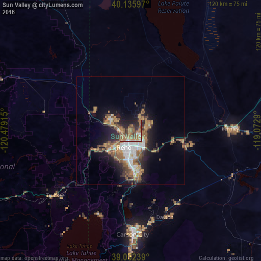
Analysis of Sun Valley night lights 2016
Square area 10x10 km:
 3.41%
3.41%90-99
5.03%80-89
3.73%70-79
14.29%60-69
14.12%50-59
15.26%40-49
9.25%30-39
5.19%20-29
12.82%10-19
16.88%0-9
0%Square area 50x50 km:
2.41%90-99
2.1%80-89
0.75%70-79
2.81%60-69
2.9%50-59
2.86%40-49
2.1%30-39
2.13%20-29
3.3%10-19
7.1%0-9
71.53%Clear (daylight) street map image can be seen on geolist.org.
Map coordinates:
40° 8' 9.5" North, 120° 28' 44.9" West
39° 35' 46.7" North, 119° 46' 33.7" West
39° 3' 8.6" North, 119° 4' 22.4" West
Some cities around Sun Valley sort by population:
• Reno
8.1 km =5 mi,  203°
203°
• Sparks
7.1 km =4.4 mi,  163°
163°
• Fernley
44.9 km =27.9 mi,  88°
88°
• Spanish Springs
8.3 km =5.2 mi,  45°
45°
• Dayton
42.9 km =26.7 mi, 158°
• Incline Village
41.9 km =26 mi, 203°
• Cold Springs
19.5 km =12.1 mi,  298°
298°
• Lemmon Valley
7.3 km =4.5 mi,  307°
307°
5513307 (p: 19,299)
Sources (retrieved 2019-11-25):
» Earth at Night: Flat Maps 2012, 2016