Cold Springs night lights from space
Night Light of Cold Springs (Nevada) from space (United States) Src. Average luminocity for 10x10km area is 6.6558% and for 50x50km: 11.3876%.
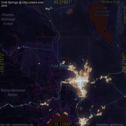
Analysis of Cold Springs night lights 2016
Square area 10x10 km:
 0%
0%90-99
0%80-89
0%70-79
2.27%60-69
1.62%50-59
0.16%40-49
1.3%30-39
2.76%20-29
0.16%10-19
2.6%0-9
89.12%Square area 50x50 km:
2.14%90-99
1.82%80-89
0.51%70-79
2.19%60-69
2.29%50-59
2.19%40-49
1.56%30-39
1.44%20-29
2.35%10-19
4.26%0-9
79.24%Clear (daylight) street map image can be seen on geolist.org.
Map coordinates:
40° 13' 9.2" North, 120° 40' 47" West
39° 40' 48.7" North, 119° 58' 35.7" West
39° 8' 12.9" North, 119° 16' 24.5" West
Some cities around Cold Springs sort by population:
• Reno
21.8 km =13.5 mi,  140°
140°
• Sparks
25.1 km =15.6 mi,  130°
130°
• Sun Valley
19.5 km =12.1 mi,  118°
118°
• Truckee
43 km =26.7 mi,  204°
204°
• Spanish Springs
23.3 km =14.5 mi,  98°
98°
• Dayton
59.3 km =36.8 mi,  146°
146°
• Incline Village
47.7 km =29.6 mi,  179°
179°
• Lemmon Valley
12.4 km =7.7 mi,  113°
113°
5502015 (p: 8,544)
Sources (retrieved 2019-11-25):
» Earth at Night: Flat Maps 2012, 2016