Spanish Springs night lights from space
Night Light of Spanish Springs (Nevada) from space (United States) Src. Average luminocity for 10x10km area is 31.8977% and for 50x50km: 14.112%.
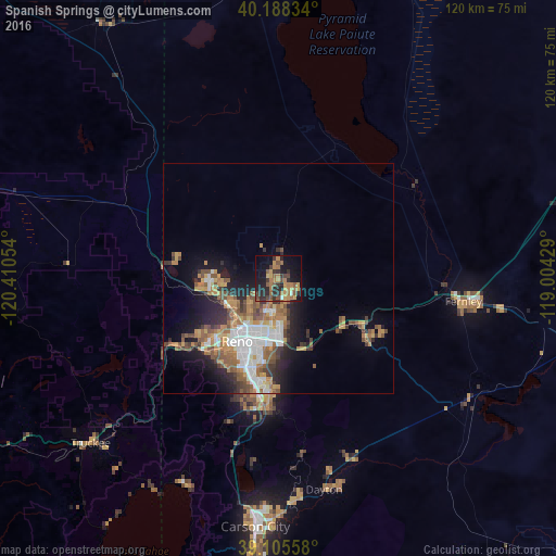
Analysis of Spanish Springs night lights 2016
Square area 10x10 km:
 0.32%
0.32%90-99
0.97%80-89
0.81%70-79
9.58%60-69
10.55%50-59
7.14%40-49
4.71%30-39
7.14%20-29
12.18%10-19
23.7%0-9
22.89%Square area 50x50 km:
2.37%90-99
2.05%80-89
0.69%70-79
2.72%60-69
2.68%50-59
2.77%40-49
1.96%30-39
1.88%20-29
3.12%10-19
6.34%0-9
73.42%Clear (daylight) street map image can be seen on geolist.org.
Map coordinates:
40° 11' 18" North, 120° 24' 37.9" West
39° 38' 56.7" North, 119° 42' 26.7" West
39° 6' 20.1" North, 119° 0' 15.4" West
Some cities around Spanish Springs sort by population:
• Reno
16.1 km =10 mi,  214°
214°
• Sparks
13.3 km =8.3 mi,  196°
196°
• Fernley
39.3 km =24.4 mi,  96°
96°
• Sun Valley
8.3 km =5.2 mi,  225°
225°
• Dayton
46.8 km =29.1 mi,  167°
167°
• Cold Springs
23.3 km =14.5 mi,  278°
278°
• Silver Springs
48.9 km =30.4 mi,  122°
122°
• Lemmon Valley
11.7 km =7.3 mi,  262°
262°
5512827 (p: 15,064)
Sources (retrieved 2019-11-25):
» Earth at Night: Flat Maps 2012, 2016