Frederickson night lights from space
Night Light of Frederickson (Washington) from space (United States) Src. Average luminocity for 10x10km area is 58.6818% and for 50x50km: 28.5368%.
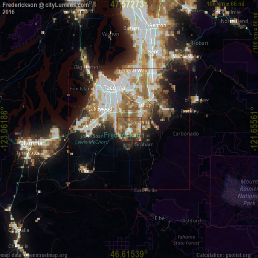
Analysis of Frederickson night lights 2016
Square area 10x10 km:
 4.4%
4.4%90-99
7.24%80-89
4.4%70-79
7.53%60-69
18.18%50-59
28.41%40-49
13.78%30-39
8.1%20-29
5.82%10-19
2.13%0-9
0%Square area 50x50 km:
6.94%90-99
5.74%80-89
2.29%70-79
3.4%60-69
4.99%50-59
5.34%40-49
3.43%30-39
3.11%20-29
4.77%10-19
6.9%0-9
53.09%Clear (daylight) street map image can be seen on geolist.org.
Map coordinates:
47° 34' 21.8" North, 123° 3' 42.7" West
47° 5' 46.4" North, 122° 21' 31.4" West
46° 36' 55.4" North, 121° 39' 20.2" West
Some cities around Frederickson sort by population:
• South Hill
8.4 km =5.2 mi,  53°
53°
• Parkland
8.7 km =5.4 mi,  319°
319°
• Spanaway
5.8 km =3.6 mi,  278°
278°
• Graham
6.9 km =4.3 mi,  134°
134°
• Elk Plain
5.6 km =3.5 mi,  211°
211°
• Midland
8.6 km =5.3 mi,  336°
336°
• Summit
7.3 km =4.5 mi,  0°
0°
• Summit View
4.5 km =2.8 mi,  6°
6°
5795011 (p: 18,719)
Sources (retrieved 2019-11-25):
» Earth at Night: Flat Maps 2012, 2016