Stratham Station night lights from space
Night Light of Stratham Station (New Hampshire) from space (United States) Src. Average luminocity for 10x10km area is 13.2159% and for 50x50km: 13.552%.
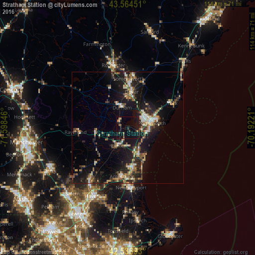
Analysis of Stratham Station night lights 2016
Square area 10x10 km:
 0%
0%90-99
0.32%80-89
0.95%70-79
1.59%60-69
2.22%50-59
1.27%40-49
1.75%30-39
1.27%20-29
3.02%10-19
24.92%0-9
62.7%Square area 50x50 km:
1.07%90-99
1.8%80-89
1.65%70-79
1.49%60-69
1.67%50-59
2.1%40-49
1.96%30-39
2.35%20-29
4.84%10-19
13.63%0-9
67.44%Clear (daylight) street map image can be seen on geolist.org.
Map coordinates:
43° 33' 52.2" North, 71° 35' 54.5" West
43° 3' 10.3" North, 70° 53' 43.2" West
42° 32' 12.9" North, 70° 11' 32" West
Some cities around Stratham Station sort by population:
• Dover
16.2 km =10.1 mi,  6°
6°
• Portsmouth
11.5 km =7.1 mi,  76°
76°
• Durham
9.4 km =5.8 mi,  344°
344°
• Hampton
13.6 km =8.5 mi,  160°
160°
• Exeter
9 km =5.6 mi,  208°
208°
• Eliot
13.6 km =8.5 mi,  34°
34°
• Newmarket
4.6 km =2.9 mi,  315°
315°
• Rye
11 km =6.8 mi,  113°
113°
5093259 (p: 6,949)
Sources (retrieved 2019-11-25):
» Earth at Night: Flat Maps 2012, 2016