Exeter night lights from space
Night Light of Exeter (New Hampshire) from space (United States) Src. Average luminocity for 10x10km area is 21.5159% and for 50x50km: 16.2489%.
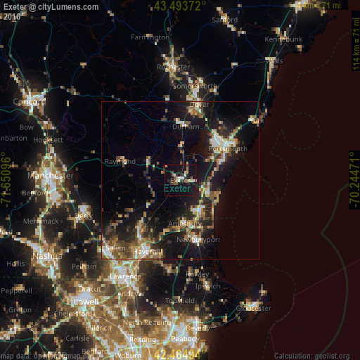
Analysis of Exeter night lights 2016
Square area 10x10 km:
 2.38%
2.38%90-99
3.17%80-89
1.27%70-79
2.38%60-69
1.9%50-59
2.06%40-49
4.29%30-39
2.22%20-29
6.83%10-19
34.44%0-9
39.05%Square area 50x50 km:
1.51%90-99
2.21%80-89
1.81%70-79
1.77%60-69
2.18%50-59
3.04%40-49
2.44%30-39
2.87%20-29
5.56%10-19
14.42%0-9
62.17%Clear (daylight) street map image can be seen on geolist.org.
Map coordinates:
43° 29' 37.4" North, 71° 39' 3.5" West
42° 58' 53.3" North, 70° 56' 52.2" West
42° 27' 53.8" North, 70° 14' 41" West
Some cities around Exeter sort by population:
• Amesbury
13.8 km =8.6 mi,  173°
173°
• Durham
17 km =10.6 mi,  5°
5°
• Hampton
10.1 km =6.3 mi,  118°
118°
• Seabrook
11.5 km =7.1 mi,  147°
147°
• Stratham Station
9 km =5.6 mi,  28°
28°
• Kingston
9.9 km =6.2 mi,  239°
239°
• Newmarket
11.3 km =7 mi, 5°
• Rye
14.8 km =9.2 mi,  76°
76°
5085966 (p: 9,242)
Sources (retrieved 2019-11-25):
» Earth at Night: Flat Maps 2012, 2016