Stillwater night lights from space
Night Light of Stillwater (Minnesota) from space (United States) Src. Average luminocity for 10x10km area is 31.9015% and for 50x50km: 21.9937%.
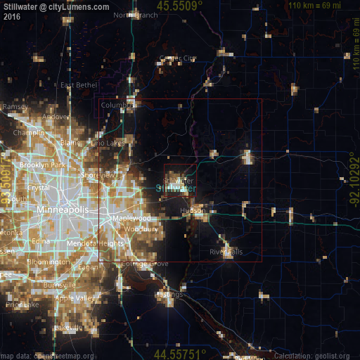
Analysis of Stillwater night lights 2016
Square area 10x10 km:
 4.24%
4.24%90-99
6.06%80-89
3.64%70-79
1.36%60-69
3.03%50-59
5.45%40-49
9.55%30-39
3.48%20-29
8.94%10-19
27.27%0-9
26.97%Square area 50x50 km:
4.15%90-99
4%80-89
2.07%70-79
3.08%60-69
4.04%50-59
3.61%40-49
3.3%30-39
2.05%20-29
3.79%10-19
9.11%0-9
60.79%Clear (daylight) street map image can be seen on geolist.org.
Map coordinates:
45° 33' 3.2" North, 93° 30' 33" West
45° 3' 22.9" North, 92° 48' 21.7" West
44° 33' 27" North, 92° 6' 10.5" West
Some cities around Stillwater sort by population:
• Maplewood
18.8 km =11.7 mi,  232°
232°
• Oakdale
16.2 km =10.1 mi, 230°
• White Bear Lake
16.3 km =10.1 mi,  281°
281°
• Hugo
18.7 km =11.6 mi,  308°
308°
• Hudson
9.9 km =6.2 mi,  156°
156°
• North Saint Paul
15.4 km =9.6 mi,  251°
251°
• Lake Elmo
8.9 km =5.5 mi,  220°
220°
• Mahtomedi
11.5 km =7.1 mi, 277°
5048814 (p: 18,924)
Sources (retrieved 2019-11-25):
» Earth at Night: Flat Maps 2012, 2016