Lake Elmo night lights from space
Night Light of Lake Elmo (Minnesota) from space (United States) Src. Average luminocity for 10x10km area is 27.5857% and for 50x50km: 31.0636%.
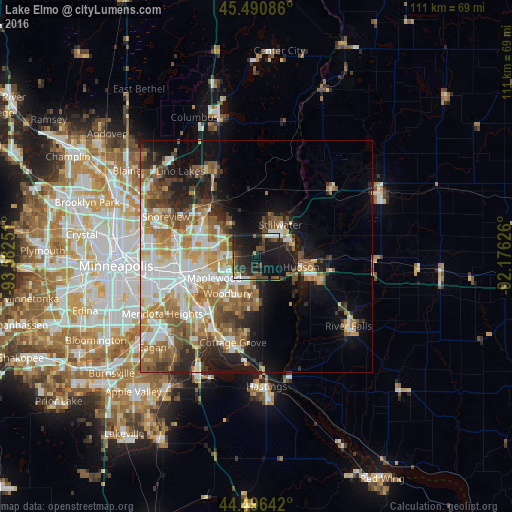
Analysis of Lake Elmo night lights 2016
Square area 10x10 km:
 2.54%
2.54%90-99
2.06%80-89
2.06%70-79
0.48%60-69
1.9%50-59
3.02%40-49
10.32%30-39
7.46%20-29
18.1%10-19
45.4%0-9
6.67%Square area 50x50 km:
6.61%90-99
5.94%80-89
3.04%70-79
4.13%60-69
6.01%50-59
4.7%40-49
4.34%30-39
3.02%20-29
5.28%10-19
10.68%0-9
46.26%Clear (daylight) street map image can be seen on geolist.org.
Map coordinates:
45° 29' 27.1" North, 93° 34' 57" West
44° 59' 44.9" North, 92° 52' 45.8" West
44° 29' 47.1" North, 92° 10' 34.5" West
Some cities around Lake Elmo sort by population:
• Woodbury
10.2 km =6.3 mi,  218°
218°
• Maplewood
10.3 km =6.4 mi,  242°
242°
• Oakdale
7.7 km =4.8 mi, 241°
• White Bear Lake
14.2 km =8.8 mi,  313°
313°
• Stillwater
8.9 km =5.5 mi,  40°
40°
• Hudson
9.9 km =6.2 mi,  103°
103°
• North Saint Paul
9 km =5.6 mi,  281°
281°
• Mahtomedi
10 km =6.2 mi,  325°
325°
5033762 (p: 8,406)
Sources (retrieved 2019-11-25):
» Earth at Night: Flat Maps 2012, 2016