St. Marys night lights from space
Night Light of St. Marys (Georgia) from space (United States) Src. Average luminocity for 10x10km area is 28.1469% and for 50x50km: 11.4983%.
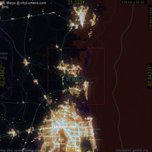
Analysis of St. Marys night lights 2016
Square area 10x10 km:
 0.7%
0.7%90-99
0.7%80-89
2.45%70-79
8.22%60-69
9.97%50-59
0.87%40-49
4.37%30-39
7.34%20-29
4.37%10-19
33.22%0-9
27.8%Square area 50x50 km:
0.51%90-99
0.62%80-89
0.37%70-79
2.45%60-69
3.58%50-59
1.32%40-49
1.76%30-39
3.12%20-29
3.17%10-19
11.97%0-9
71.12%Clear (daylight) street map image can be seen on geolist.org.
Map coordinates:
31° 19' 58.8" North, 82° 14' 58.6" West
30° 43' 49.8" North, 81° 32' 47.4" West
30° 7' 27.2" North, 80° 50' 36.1" West
Some cities around St. Marys sort by population:
• Jacksonville
45.5 km =28.3 mi,  193°
193°
• Kingsland
15.7 km =9.8 mi,  299°
299°
• Brunswick
46.9 km =29.1 mi,  6°
6°
• Atlantic Beach
46.3 km =28.8 mi,  162°
162°
• Fernandina Beach
10.5 km =6.5 mi,  130°
130°
• Yulee
12.4 km =7.7 mi,  207°
207°
• Nassau Village-Ratliff
35 km =21.7 mi,  225°
225°
• Folkston
45.8 km =28.5 mi,  284°
284°
4220629 (p: 17,968)
Sources (retrieved 2019-11-25):
» Earth at Night: Flat Maps 2012, 2016