Nassau Village-Ratliff night lights from space
Night Light of Nassau Village-Ratliff (Florida) from space (United States) Src. Average luminocity for 10x10km area is 14.6044% and for 50x50km: 25.5425%.
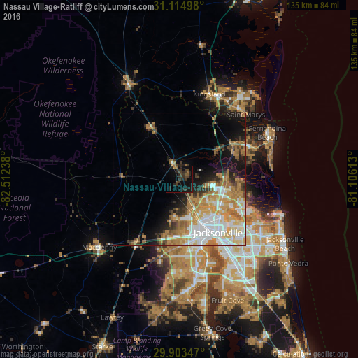
Analysis of Nassau Village-Ratliff night lights 2016
Square area 10x10 km:
 0%
0%90-99
0%80-89
0%70-79
0.55%60-69
1.65%50-59
1.47%40-49
4.95%30-39
8.24%20-29
11.72%10-19
11.54%0-9
59.89%Square area 50x50 km:
5.48%90-99
4.89%80-89
2.83%70-79
5.4%60-69
5.19%50-59
2.14%40-49
2.01%30-39
2.57%20-29
2.97%10-19
8.27%0-9
58.26%Clear (daylight) street map image can be seen on geolist.org.
Map coordinates:
31° 6' 53.9" North, 82° 30' 44.6" West
30° 30' 40" North, 81° 48' 33.3" West
29° 54' 12.5" North, 81° 6' 22.1" West
Some cities around Nassau Village-Ratliff sort by population:
• Jacksonville
24.8 km =15.4 mi,  143°
143°
• Oakleaf Plantation
37.9 km =23.5 mi,  183°
183°
• St. Marys
35 km =21.7 mi,  45°
45°
• Kingsland
34.1 km =21.2 mi,  19°
19°
• Bellair-Meadowbrook Terrace
37.5 km =23.3 mi,  170°
170°
• Fernandina Beach
37.6 km =23.4 mi,  62°
62°
• Yulee
23.6 km =14.7 mi, 55°
• Macclenny
39.3 km =24.4 mi,  229°
229°
7260484 (p: 5,337)
Sources (retrieved 2019-11-25):
» Earth at Night: Flat Maps 2012, 2016