Folkston night lights from space
Night Light of Folkston (Georgia) from space (United States) Src. Average luminocity for 10x10km area is 16.3584% and for 50x50km: 1.3272%.
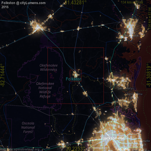
Analysis of Folkston night lights 2016
Square area 10x10 km:
 0.35%
0.35%90-99
1.05%80-89
0%70-79
4.2%60-69
6.64%50-59
1.4%40-49
4.02%30-39
1.92%20-29
2.97%10-19
4.55%0-9
72.9%Square area 50x50 km:
0.01%90-99
0.04%80-89
0.03%70-79
0.32%60-69
0.42%50-59
0.15%40-49
0.36%30-39
0.26%20-29
0.29%10-19
0.29%0-9
97.83%Clear (daylight) street map image can be seen on geolist.org.
Map coordinates:
31° 25' 58.1" North, 82° 42' 52" West
30° 49' 51.4" North, 82° 0' 40.7" West
30° 13' 31.1" North, 81° 18' 29.5" West
Some cities around Folkston sort by population:
• St. Marys
45.8 km =28.5 mi,  104°
104°
• Kingsland
30.9 km =19.2 mi, 96°
• Brunswick
60.9 km =37.8 mi,  54°
54°
• Waycross
53.7 km =33.4 mi,  322°
322°
• Fernandina Beach
55.4 km =34.4 mi,  108°
108°
• Yulee
44.6 km =27.7 mi,  119°
119°
• Macclenny
61.9 km =38.5 mi,  189°
189°
• Nassau Village-Ratliff
40.5 km =25.2 mi,  151°
151°
4195600 (p: 5,247)
Sources (retrieved 2019-11-25):
» Earth at Night: Flat Maps 2012, 2016