Kingsland night lights from space
Night Light of Kingsland (Georgia) from space (United States) Src. Average luminocity for 10x10km area is 35.9178% and for 50x50km: 10.1523%.
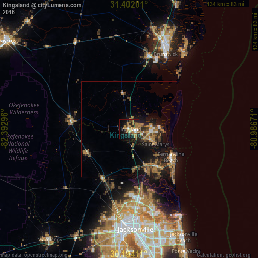
Analysis of Kingsland night lights 2016
Square area 10x10 km:
 2.62%
2.62%90-99
2.8%80-89
0.7%70-79
10.84%60-69
14.51%50-59
3.85%40-49
2.97%30-39
7.34%20-29
8.92%10-19
23.95%0-9
21.5%Square area 50x50 km:
0.52%90-99
0.58%80-89
0.4%70-79
2.43%60-69
3.3%50-59
1.28%40-49
1.54%30-39
2.54%20-29
2.45%10-19
8.57%0-9
76.4%Clear (daylight) street map image can be seen on geolist.org.
Map coordinates:
31° 24' 7.2" North, 82° 23' 34.7" West
30° 47' 59.9" North, 81° 41' 23.4" West
30° 11' 38.8" North, 80° 59' 12.2" West
Some cities around Kingsland sort by population:
• St. Marys
15.7 km =9.8 mi,  119°
119°
• Brunswick
43.3 km =26.9 mi,  25°
25°
• Saint Simon Mills
49.2 km =30.6 mi, 33°
• Fernandina Beach
26.1 km =16.2 mi, 123°
• Yulee
20.3 km =12.6 mi,  156°
156°
• Dock Junction
47.7 km =29.6 mi,  20°
20°
• Nassau Village-Ratliff
34.1 km =21.2 mi,  199°
199°
• Folkston
30.9 km =19.2 mi,  276°
276°
4204007 (p: 16,487)
Sources (retrieved 2019-11-25):
» Earth at Night: Flat Maps 2012, 2016