Spring Hill night lights from space
Night Light of Spring Hill (Kansas) from space (United States) Src. Average luminocity for 10x10km area is 15.8895% and for 50x50km: 22.4252%.
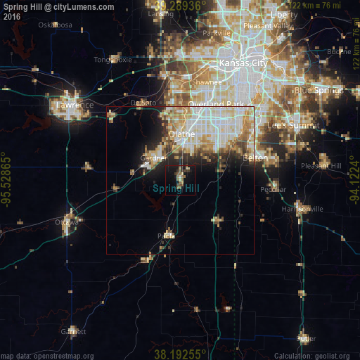
Analysis of Spring Hill night lights 2016
Square area 10x10 km:
 0%
0%90-99
2.04%80-89
2.04%70-79
0.51%60-69
2.38%50-59
5.1%40-49
3.4%30-39
2.89%20-29
1.02%10-19
18.88%0-9
61.73%Square area 50x50 km:
4.89%90-99
6.27%80-89
3.44%70-79
2.64%60-69
2.74%50-59
1.92%40-49
1.84%30-39
1.96%20-29
3.32%10-19
5.56%0-9
65.41%Clear (daylight) street map image can be seen on geolist.org.
Map coordinates:
39° 17' 21.7" North, 95° 31' 43.1" West
38° 44' 35" North, 94° 49' 31.9" West
38° 11' 33.2" North, 94° 7' 20.6" West
Some cities around Spring Hill sort by population:
• Overland Park
29.8 km =18.5 mi,  26°
26°
• Olathe
15.4 km =9.6 mi,  2°
2°
• Lenexa
24.7 km =15.3 mi,  18°
18°
• Grandview
29.9 km =18.6 mi,  57°
57°
• Belton
26.6 km =16.5 mi,  73°
73°
• Gardner
11.6 km =7.2 mi,  310°
310°
• De Soto
29 km =18 mi,  334°
334°
• Paola
19.6 km =12.2 mi,  193°
193°
4279847 (p: 5,981)
Sources (retrieved 2019-11-25):
» Earth at Night: Flat Maps 2012, 2016