Thompsonville night lights from space
Night Light of Thompsonville (Connecticut) from space (United States) Src. Average luminocity for 10x10km area is 52.8841% and for 50x50km: 34.4974%.
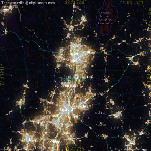
Analysis of Thompsonville night lights 2016
Square area 10x10 km:
 3.81%
3.81%90-99
5.4%80-89
12.38%70-79
6.19%60-69
11.11%50-59
11.43%40-49
10.16%30-39
18.1%20-29
16.35%10-19
5.08%0-9
0%Square area 50x50 km:
4.63%90-99
5.57%80-89
6.02%70-79
4.9%60-69
6.38%50-59
5.74%40-49
4.89%30-39
5.65%20-29
8.28%10-19
10.25%0-9
37.7%Clear (daylight) street map image can be seen on geolist.org.
Map coordinates:
42° 31' 2.8" North, 73° 18' 7.6" West
41° 59' 49.3" North, 72° 35' 56.3" West
41° 28' 20.5" North, 71° 53' 45.1" West
Some cities around Thompsonville sort by population:
• Springfield
11.6 km =7.2 mi,  3°
3°
• Enfield
2.4 km =1.5 mi,  165°
165°
• Agawam
8.2 km =5.1 mi,  350°
350°
• Longmeadow
6 km =3.7 mi,  12°
12°
• East Longmeadow
10.4 km =6.5 mi,  43°
43°
• Windsor Locks
7.9 km =4.9 mi,  197°
197°
• Southwood Acres
4.5 km =2.8 mi,  149°
149°
• Sherwood Manor
3.4 km =2.1 mi,  57°
57°
4844200 (p: 8,577)
Sources (retrieved 2019-11-25):
» Earth at Night: Flat Maps 2012, 2016