Southeast Arcadia night lights from space
Night Light of Southeast Arcadia (Florida) from space (United States) Src. Average luminocity for 10x10km area is 25.358% and for 50x50km: 5.4184%.
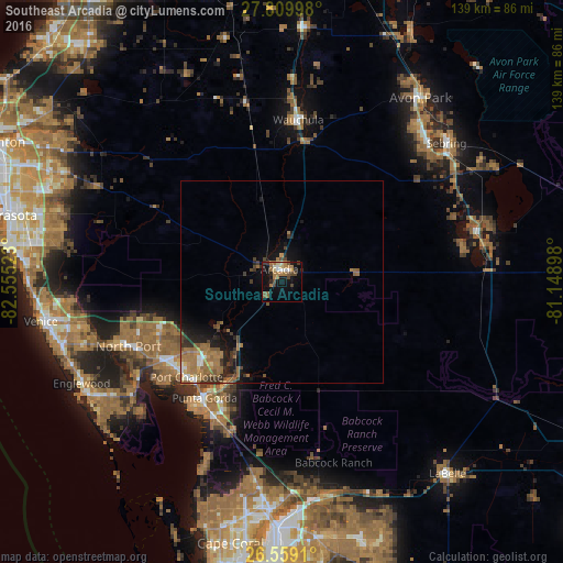
Analysis of Southeast Arcadia night lights 2016
Square area 10x10 km:
 2.08%
2.08%90-99
2.46%80-89
3.03%70-79
1.14%60-69
10.04%50-59
4.55%40-49
4.36%30-39
4.36%20-29
3.03%10-19
18.18%0-9
46.78%Square area 50x50 km:
0.29%90-99
0.43%80-89
0.33%70-79
0.43%60-69
2.47%50-59
1.2%40-49
0.85%30-39
1.12%20-29
1.15%10-19
3.25%0-9
88.49%Clear (daylight) street map image can be seen on geolist.org.
Map coordinates:
27° 48' 35.9" North, 82° 33' 18.8" West
27° 11' 10.6" North, 81° 51' 7.6" West
26° 33' 32.8" North, 81° 8' 56.3" West
Some cities around Southeast Arcadia sort by population:
• North Port
41.1 km =25.5 mi,  247°
247°
• Port Charlotte
33.2 km =20.6 mi,  225°
225°
• Punta Gorda Isles
37.4 km =23.2 mi,  216°
216°
• Punta Gorda
34.3 km =21.3 mi,  213°
213°
• Sebring
53.2 km =33.1 mi,  49°
49°
• Arcadia
3.3 km =2.1 mi,  349°
349°
• Fort Myers Shores
54.1 km =33.6 mi,  168°
168°
• Warm Mineral Springs
42.8 km =26.6 mi, 250°
7260157 (p: 6,554)
Sources (retrieved 2019-11-25):
» Earth at Night: Flat Maps 2012, 2016