Sebring night lights from space
Night Light of Sebring (Florida) from space (United States) Src. Average luminocity for 10x10km area is 46.7103% and for 50x50km: 8.2292%.
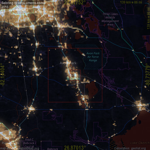
Analysis of Sebring night lights 2016
Square area 10x10 km:
 5.95%
5.95%90-99
5.16%80-89
1.59%70-79
3.57%60-69
18.85%50-59
12.1%40-49
7.54%30-39
9.52%20-29
14.68%10-19
17.66%0-9
3.37%Square area 50x50 km:
0.51%90-99
0.56%80-89
0.33%70-79
0.43%60-69
2.6%50-59
2.13%40-49
1.78%30-39
1.76%20-29
2.5%10-19
6.58%0-9
80.82%Clear (daylight) street map image can be seen on geolist.org.
Map coordinates:
28° 7' 3.1" North, 82° 8' 38.5" West
27° 29' 44.1" North, 81° 26' 27.3" West
26° 52' 12.5" North, 80° 44' 16" West
Some cities around Sebring sort by population:
• Bartow
59.6 km =37 mi,  318°
318°
• Lake Wales
47.3 km =29.4 mi,  342°
342°
• Avon Park
12.9 km =8 mi,  330°
330°
• Cypress Gardens
60.6 km =37.7 mi, 336°
• Arcadia
51.6 km =32.1 mi,  232°
232°
• Southeast Arcadia
53.2 km =33.1 mi, 229°
• Fort Meade
45.6 km =28.3 mi,  308°
308°
• Wahneta
58.1 km =36.1 mi, 331°
4172383 (p: 10,497)
Sources (retrieved 2019-11-25):
» Earth at Night: Flat Maps 2012, 2016