Sonoma night lights from space
Night Light of Sonoma (California) from space (United States) Src. Average luminocity for 10x10km area is 18.983% and for 50x50km: 14.6077%.
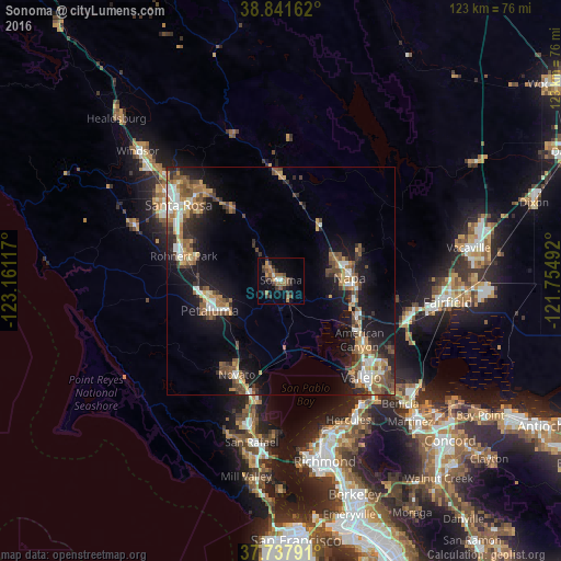
Analysis of Sonoma night lights 2016
Square area 10x10 km:
 0.68%
0.68%90-99
0.68%80-89
0.68%70-79
2.72%60-69
5.61%50-59
5.44%40-49
2.55%30-39
8.33%20-29
2.89%10-19
6.12%0-9
64.29%Square area 50x50 km:
1.67%90-99
1.86%80-89
1.02%70-79
2.25%60-69
2.43%50-59
2.82%40-49
2.81%30-39
2.32%20-29
3.14%10-19
11.17%0-9
68.52%Clear (daylight) street map image can be seen on geolist.org.
Map coordinates:
38° 50' 29.8" North, 123° 9' 40.2" West
38° 17' 30.7" North, 122° 27' 28.9" West
37° 44' 16.5" North, 121° 45' 17.7" West
Some cities around Sonoma sort by population:
• Napa
15.1 km =9.4 mi,  87°
87°
• Petaluma
16.9 km =10.5 mi,  247°
247°
• Novato
22.7 km =14.1 mi,  205°
205°
• Rohnert Park
21.9 km =13.6 mi,  284°
284°
• American Canyon
21.6 km =13.4 mi,  127°
127°
• Cotati
22.1 km =13.7 mi, 280°
• Boyes Hot Springs
3.2 km =2 mi,  319°
319°
• Saint Helena
23.7 km =14.7 mi,  357°
357°
5397095 (p: 11,037)
Sources (retrieved 2019-11-25):
» Earth at Night: Flat Maps 2012, 2016