Snyderville night lights from space
Night Light of Snyderville (Utah) from space (United States) Src. Average luminocity for 10x10km area is 19.7435% and for 50x50km: 7.1245%.
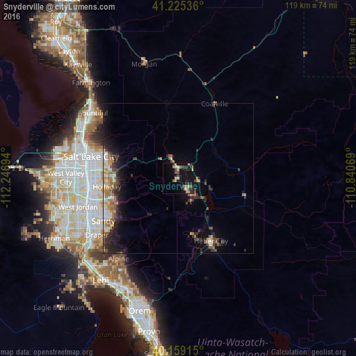
Analysis of Snyderville night lights 2016
Square area 10x10 km:
 1.14%
1.14%90-99
1.14%80-89
4.06%70-79
3.73%60-69
2.11%50-59
2.44%40-49
2.11%30-39
4.38%20-29
5.84%10-19
19.48%0-9
53.57%Square area 50x50 km:
0.7%90-99
0.83%80-89
0.65%70-79
1.17%60-69
1.19%50-59
1.07%40-49
0.93%30-39
1.4%20-29
2.63%10-19
4.51%0-9
84.92%Clear (daylight) street map image can be seen on geolist.org.
Map coordinates:
41° 13' 31.3" North, 112° 14' 49" West
40° 41' 39.8" North, 111° 32' 37.7" West
40° 9' 32.9" North, 110° 50' 26.5" West
Some cities around Snyderville sort by population:
• Cottonwood Heights
24 km =14.9 mi,  249°
249°
• Holladay
23.9 km =14.9 mi,  263°
263°
• East Millcreek
22.5 km =14 mi,  271°
271°
• Canyon Rim
23.5 km =14.6 mi, 273°
• Heber City
23.6 km =14.7 mi,  152°
152°
• Park City
6.6 km =4.1 mi,  144°
144°
• Summit Park
8.1 km =5 mi,  315°
315°
• Mount Olympus
20.7 km =12.9 mi, 267°
5781609 (p: 5,612)
Sources (retrieved 2019-11-25):
» Earth at Night: Flat Maps 2012, 2016