Sierra Vista Southeast night lights from space
Night Light of Sierra Vista Southeast (Arizona) from space (United States) Src. Average luminocity for 10x10km area is 7.2115% and for 50x50km: 4.3394%.
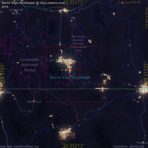
Analysis of Sierra Vista Southeast night lights 2016
Square area 10x10 km:
 0%
0%90-99
0%80-89
0%70-79
1.92%60-69
0.87%50-59
2.1%40-49
1.4%30-39
2.8%20-29
2.1%10-19
5.59%0-9
83.22%Square area 50x50 km:
0.33%90-99
0.35%80-89
0.26%70-79
0.91%60-69
1.46%50-59
0.37%40-49
0.36%30-39
0.6%20-29
1.24%10-19
3.59%0-9
90.52%Clear (daylight) street map image can be seen on geolist.org.
Map coordinates:
32° 3' 6.2" North, 110° 55' 10.2" West
31° 27' 13.9" North, 110° 12' 58.9" West
30° 51' 7.7" North, 109° 30' 47.7" West
Some cities around Sierra Vista Southeast sort by population:
• Nogales, MX
70.8 km =44 mi,  256°
256°
• Agua Prieta, MX
64.8 km =40.3 mi,  102°
102°
• Cananea, MX
52.4 km =32.6 mi,  187°
187°
• Nogales
69.3 km =43.1 mi, 259°
• Rio Rico
72.1 km =44.8 mi,  271°
271°
• Douglas
64.8 km =40.3 mi, 100°
• Naco, MX
29.2 km =18.1 mi,  118°
118°
• Bisbee
27.3 km =17 mi,  91°
91°
7261785 (p: 14,797)
Sources (retrieved 2019-11-25):
» Earth at Night: Flat Maps 2012, 2016